Perhaps sensing a ripe opportunity, PJM Interconnection has opened a project window to solve multiple thermal overloads in the 4-state area. PJM says all these overloads are caused by:
- Proliferation of data centers in Northern Virginia that have caused increased load.
- Generator deactivations - i.e. closing of large baseload fossil fuel electric generators in the DC and Baltimore suburbs.
- Need for bulk electricity transfers from places where plants have not closed (i.e. West Virginia, Pennsylvania.)
- Offshore wind.
- New planning procedures.
A map of the overloads looks like this:
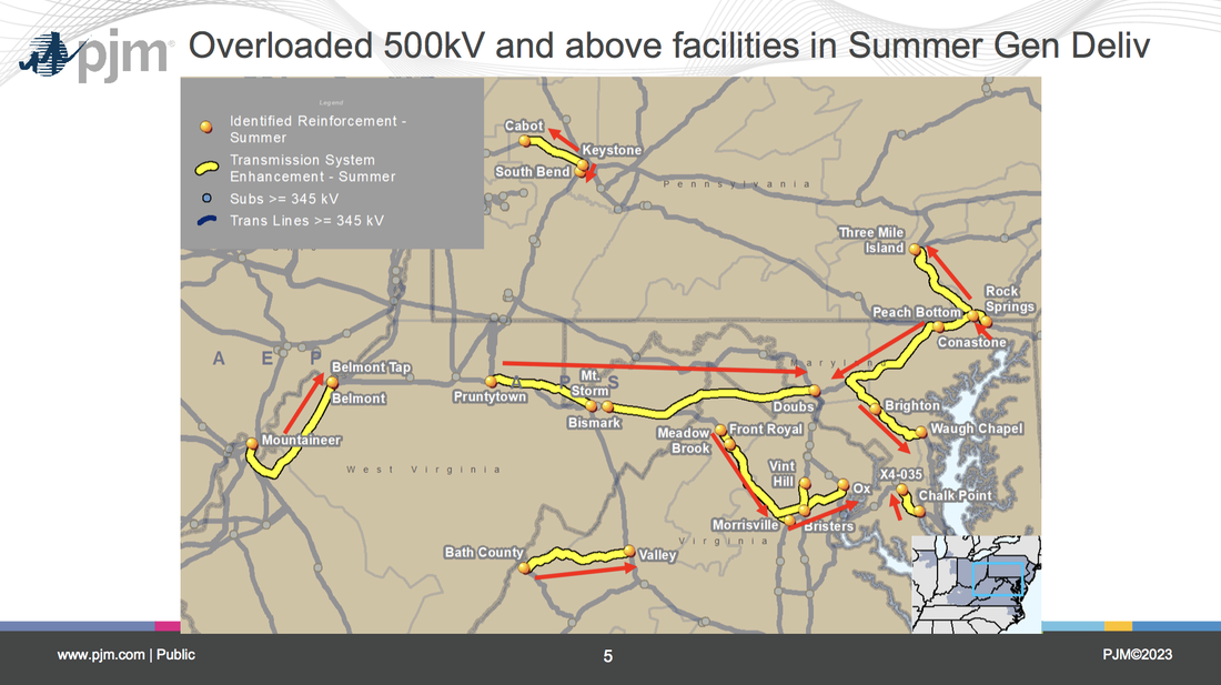
PJM's new procedures call for competitive transmission proposals. Instead of awarding a massive project like PATH to its favored incumbent transmission owners in a smoky back room, PJM is now required to post a "problem" window to solicit possible solutions submitted by any company. PJM publicly posts solutions without identifying who proposed them, then makes a decision on which idea best solves the problem. Except in this instance, the problem was so large it drew solutions consisting of 72 Proposals from 10 entities, of which 7 are incumbents and 3 are non-incumbents. 16 Projects are upgrades, while 50 are Greenfield. Greenfield means new transmission (or substations) on new rights-of-way. There are projects proposed all over the map, from eastern Maryland to northern Virginia to southeastern Pennsylvania to eastern West Virginia. I'm only going to concentrate on just a few for this blog.
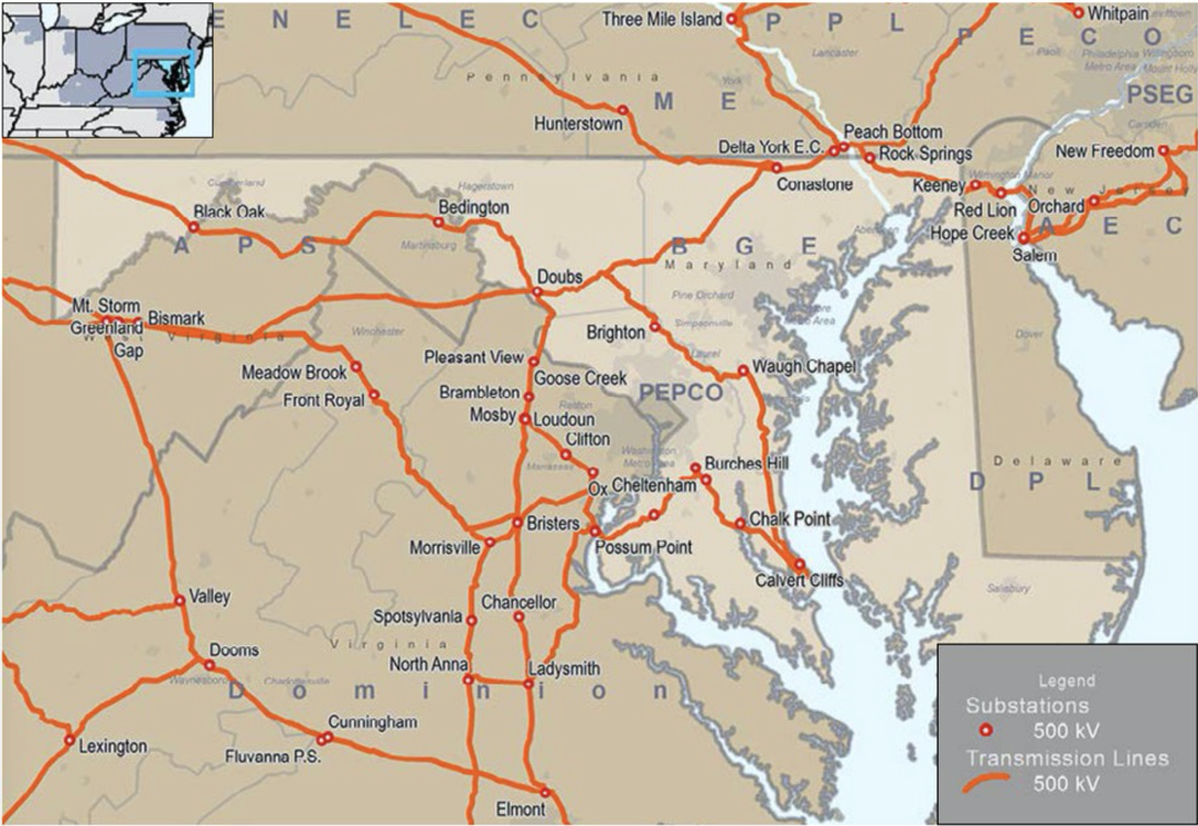
First, here's a PJM map showing existing substations and transmission lines. You're going to need it to follow along on the written routes.
First, here's a PJM map showing existing substations and transmission lines. You're going to need it to follow along on the written routes.
Black Oak - Doubs Greenfield 500kV Transmission Line
The project starts at Black Oak and heads east, paralleling the existing Black Oak - Bedington corridor, for ~6 miles. The line continues east for approximately 10 miles but strays away from the existing corridor due to infrastructure build up that has occurred around the corridor in this area. The line then heads southeast where it parallels the existing Hampshire to Ridgeley 138kV corridor for
approximately 16 miles. At this point the rebuild of the existing Hampshire to Stonewall 138kV line begins. The line will be upgraded to 500/138kV double circuit. The route follows this corridor until it meets up with the Stonewall Substation. At this point the route follows the existing Stonewall to Millville 138kV line. This line will be rebuilt to 500/138kV for its entire length. After the Millville substation the route follows the Millville to Doubs 138kV transmission line. This line is rebuilt to 500/138kV until a few spans outside of the Doubs substation. The 500kV circuit diverges from the 138kV centerline and connects into the 500kV Doubs substation.
Most high-voltage transmission projects will
require a state siting approval. To begin the siting approval process, Proposer plans to hold
pre-application meetings with the regulatory agency to introduce Proposer and the Project, as well as confirm its understanding of the process. Shortly thereafter, Proposer will simultaneously begin collecting siting data and start its outreach efforts so that public siting input is incorporated at the earliest stages of the Project. Once the Proposer identifies a preferred site/route and at least one viable alternative site/route, Proposer will carry out environmental and detailed engineering work in order to establish a highly- detailed Project plan to support the siting applications.
The project will feature a right of way width of 175 feet for the green field portion of the project. The ROW will parallel existing corridor for the first ~31 miles (the greenfield portion). For the rebuild portion, the transmission line should fit in the existing corridor, however the transmission operator may decide to expand the right-of-way.
The proposed line will cross over the Black Oak to Bedington 500kV transmission line., The proposed line will cross over the Black Oak to Junction 138kV transmission line in two locations., The proposed line will cross over the Double Tollgate to Millville 138kV transmission line., The proposed line will cross over the Hampshire to Ridgeley 138kV transmission line in three locations., The proposed line will cross over the Mt Storm to Doubs 500kV transmission line in three locations.
The preliminary design for the single circuit transmission line utilizes tubular steel monopole structures with davit arms and v-string insulators in a delta configuration. The 500kV transmission line will utilize triangular spaced triple-bundle 1272 kcmil "Bittern" ACSS/TW MA3 conductor and two optical groundwires. The preliminary design for the double circuit 500/138kV transmission line utilizes tubular steel monopole structures with davit arms and v-string insulators in a delta configuration for the 500kV circuit and davit arms and I-string insulators in a horizontal configuration for the 138kV circuit. The 500kV transmission line will utilize triangular spaced triple-bundle 1272
kcmil "Bittern" ACSS/TW MA3 conductor and the 138kV transmission line will utilize a single 1272 kcmil "Bittern" ACSS/TW MA3. The structure will contain two optical groundwires.
Check the map. This project will cross through Jefferson County, WV and rebuild the current 138kV line to double circuit with a 500kV. It also proposes to snake through the congested area on the mountain that PATH had so much trouble trying to find a right of way through. It's just too narrow with many houses just outside the right of way.
Here's another... but this one is a lot more convoluted and has many different parts. First of all, it proposes a new Bartholow substation. It doesn't give the exact location, but wasn't PATH's ginormous substation located on Bartholows Road? It's somewhere in the vicinity but they aren't sharing that yet.
Here's another... but this one is a lot more convoluted and has many different parts. First of all, it proposes a new Bartholow substation. It doesn't give the exact location, but wasn't PATH's ginormous substation located on Bartholows Road? It's somewhere in the vicinity but they aren't sharing that yet.
45F1 - New Bartholow Substation - 12 terminal
AC Air Insulated Substation (AIS): New proposed 500 - 230 kV Substation. New Breaker and a Half (BAAH) 500 kV switchyard with three (3) bays, six (6) line terminals, twelve (12) 500kV, 5000A, 63kAIC Breakers, two (2) shunt 150 MVAR capacitor banks, one (1) -300 to +500 MVAR Static VAR Compensator (SVC), two (2) 500 - 230 kV transformer banks. New BAAH 230 kV switchyard with three (3) bays, six (6) line terminals, eleven (11) 230 kV, 5000A, 80 kAIC breakers.
Environmental constraints identified are manageable through implementation of an environmental avoidance, minimization, and mitigation strategy incorporated at the beginning of the routing/siting process. Co-location with existing utilities and other infrastructure was prioritized to the greatest extent practicable to minimize the environmental impact on the landscape. The proposed site crosses no national wetland inventory (NWI) wetlands or waterbodies. Fatal flaws have not been identified for proposed site. A cultural resource professional assisted with the siting process to identify and minimize impacts to known areas with historic sensitivities. An investigation to further identify and evaluate historic properties will be conducted to determine the presence of archaeologically or historically significant resources. Federally listed species have been identified with potential to occur in the area including listed bats, but no critical habitat was identified in the area of the substation site. If suitable habitat is identified or regulations change, agency coordination and species-specific surveys will occur. The project intends to adhere to tree removal seasonal restriction windows to avoid and minimize impacts to protected birds and bats, such as the northern long-eared bat, bald eagle, and other common raptors. Erosion control best management practices and setbacks will be engineered and utilized to prevent sedimentation from leaving the site for the protection of aquatic species and to avoid water quality impacts. There are no unique or sensitive environmental concerns or impacts with the proposed substation site that cannot be addressed.
The Company is committed to working with all interested stakeholders through a robust public outreach program to address/respond to community concerns and inform the public about the project to the greatest extent practicable. The Company believes a well-designed public outreach program can have numerous benefits, including fostering a cooperative relationship with landowners and other stakeholders, expediting the regulatory permitting process, and assisting with project development. In general, the purpose of the community outreach plan is to gain community support for the project. In the affected communities, the Company’s public outreach plan will educate the public and relevant stakeholders on specific project details to enable timely regulatory approvals and construction activities. Elements of the public outreach plan will include the following: 1) Identify potential issues at an early stage by engagement with key community stakeholders at the outset; 2) Broaden the community engagement process to identify potential and relevant community benefits that can facilitate community support for the proposed project; 3) Develop a broad base of community support for the proposed project before the regulatory agencies; and 4) Develop a comprehensive administrative record documenting the community outreach process that can be presented to the regulatory agency or, in the event of a legal challenge, to the appropriate court. The outreach plan proposes to dedicate considerable time and resources in engaging the community, and specifically the affected community during the planning process to identify highly sensitive areas that have the least amount of cultural, environmental, and social impacts on the community. The plans will reflect avoidance of impacts rather than mitigation. However, in some cases, if avoidance is not possible, then the Company will involve the community in providing appropriate and practical mitigation measures. The Company will commence its public outreach activities following project award.
Of course, a new substation needs new transmission lines, and there are several proposed:
40AB1 - New two single circuit 230kV transmission lines from new Bartholow substation to new Grisham substation
General route description
The route is approximately 35 miles long. The component is two single circuit 230kV transmission lines to satisfy contingency requirements with utilizing a shared tower, however the towers can be designed in such a way that they are staggered and offset as to utilize the same ROW width as a double circuit 230kV transmission line. This provides the reliability of two single circuits and the permitting and constructability requirements similar to a single double circuit tower installation. Starting at a new dead-end structure at the new Bartholow substation, the route follows the existing Doubs - Brighton 500kV transmission ROW west - southwest for almost 8 miles, expanding the existing ROW. Minor adjustments may be needed for reducing impacts to buildings and residences. The route turns south where Bennet Creek intersects with the existing Doubs - Brighton 500kV transmission ROW and then routes on the eastern side of Sugarloaf Mountain for about 12 miles before then co-locating with the existing Doubs - Goose Creek 500KV transmission ROW. The route follows the existing transmission ROW on the eastern side, expanding the existing ROW, with slight deviation at the Leesburg Water Treatment Plant to avoid impact to operations at the facility. The route shifts underground on the north side of the Potomac River at the Leesburg Water Treatment Plant to reduce viewshed issues with crossing the river and spatial constraints on the south side of the river. The lines remain underground along the Doubs - Goose Creek 500kV ROW corridor until returning to overhead construction around the southeast corner of Crosstrail Blvd and Harry Byrd Hwy. The lines follow the Harry Byrd Hwy until turning south on the east side of Loudoun County Pkwy. The lines shift to the west side of Loudoun County Pkwy near the intersection with the Washington and Old Dominion trail to avoid conflicts with the 1757 Golf Club. The lines then share a common double circuit transmission tower for remaining duration of the route as it is less than 1 mile and is advantageous to utilize a double circuit tower for cost effectiveness.
The Project is located in the valley south of the Potomac River in Loudon County, traversing north through Montgomery and Frederick Counties in Maryland. A former agricultural region, Loudon County is now densely developed with commercial buildings and planned residential communities within commuting distance to Washington, D.C. Some industrial facilities are located to the south of the project area. Slopes are gentle, approximately 4%. The project terminates on the north side of the Potomac River in Frederick, Maryland where the topography is generally rolling. Elevations range from a low of near sea level along the Potomac River to about 875 feet. The river valley’s topography includes little steep terrain, but some steep gradients do exist adjacent to the river. These land elevations and the degree of slope have influenced land use in the watershed. The region’s relatively flat topography has made it easily accessible for development and agriculture in some areas next to the river and its tributaries.
The new right of way will have its own corridor for approximately 60% of the route length. The right of way will be an expansion of an existing transmission line corridor for approximately 35% of the route length. The right of way width will be 60 feet and it will accommodate 2-230kV lines. Approximately 5% of the route will be underground in narrower and congested areas where overhead construction was considered not feasible. Where underground transmission line segments are not sited by permits issued by the Authority Having Jurisdiction, a 40 ft wide right of way would be required for construction.
The proposed structures for each of the two proposed lines will be single circuit 230kV steel monopoles (TVVS-230) in a vertical conductor configuration. Any proposed dead-end structure will be a steel monopole. The portion of the route proposed to be underground will utilize duct bank construction with 3-cables per phase and splicing vaults at regular intervals.
43e - New 230kV transmission line from new Bartholow substation to existing Mt. Airy substation
The route is approximately 5 miles long. Starting a new deadend structure at the new Bartholow substation, the line routes northeast along the northside of the existing Conastone to Brighton 500kV transmission ROW. The line follows the existing ROW for about 4.25 miles before turning north, routing to the Mt Airy substation and then terminating at the substation.
The project is located in the Piedmont Upland portion of Maryland’s Frederick County. The Frederick Valley, through which the Monocacy flows, is nestled between the Catoctin Mountains to the west, and the lower Parrs Ridge to the east. The river valley’s topography includes little steep terrain, but some steep gradients do exist adjacent to the river. These land elevations and the degree of slope have influenced land use in the watershed. This section is underlain by metamorphic, igneous, and sedimentary materials, related to volcanic activity that occurred in Precambrian time. The region is comprised of rolling upland with herringbone texture and underlain with siltstones and quartzites.
The new right of way will be an expansion of an existing transmission line corridor for approximately 90% of the route length. The right of way will have its own corridor for approximately 10% of the route length. For approximately 1 mile, the right of way width will be 45 ft, for approximately 3.3 miles, the right of way will be 60 ft and will accommodate a portion of component 47ad within it. For approximately 0.5 miles the right of way will be 40 ft wide.
The majority, approximately 80% of the proposed structures will be single circuit 230kV steel monopoles (TVVS-230) in a vertical conductor configuration. Approximately 20% of the structures will be double circuit 230kV steel monopoles (TVVS-230DC) in a vertical conductor configuration. Any proposed dead-end structure will be a steel monopole.
47abc - New 500kV transmission line from new Goram substation to new Bartholow substation
The route is approximately 61 miles long. Starting a new dead end structure at the new Bartholow substation, the line routes northeast along the north side of the existing Brighton to Conastone 500kV transmission ROW. The line follows the existing ROW for about 49 miles and then turns north where the Otter Creek to Conastone 230kV transmission ROW coincides with the Conastone to Brighton 500kV transmission ROW. The line then follows along the west side of the Conastone to Otter Creek 230kV transmission ROW until it reaches the new Goram substation where it terminates.
The project is located in Maryland’s Frederick, Carroll and Baltimroe counties east of the Monocacy River. The Frederick Valley, through which the Monocacy flows, is nestled between the Catoctin Mountains to the west, and the lower Parrs Ridge to the east. The river valley’s topography includes little steep terrain, but some steep gradients do exist adjacent to the river. These land elevations and the degree of slope have influenced land use in the watershed. The region’s relatively flat topography has made it easily accessible for development and agriculture in some areas next to the river and its tributaries. The project continues north into the Piedmone Upland area of York County, Pennsylvania, characterized by rolling hills and valleys, generally with gentle to moderately steep slopes. However, steeper slopes with narrow valley bottoms dominate near the Susquehanna River. Many higher ridges are underlain by more resistant bedrock such as quartzite. This Section was formed by fluvial erosion and some peri-glacial wasting and averages about 600-700 feet in elevation. The drainage pattern of the area is considered to be dendritic. Slopes in the range of 0-8% are common throughout York County.
The proposed structures will be single circuit 500kV steel monopoles (TVVS-500) in a vertical delta configuration. Any proposed deadend structure will either be a 3-pole, one phase per pole configuration.
There may be more we haven't found yet. PJM's plan is to review the submitted proposals and provide more updates at the July TEAC meeting. PJM is targeting Dec 2023 Board Approval – Oct and Nov TEAC 1st and 2nd reads. Hopefully PJM will provide a full list at the July meeting, along with its preliminary evaluation and ranking of proposed projects. None of these ideas have been accepted and ordered by PJM yet, but... get ready... they could be.
It's been really quiet in our area since PATH died but now the push is on nationally to double or triple the amount of transmission built. For every transmission line you see now, there will be two new ones. That's a lot of transmission! And if you haven't been following along for the past decade (the Post-PATH era of peaceful rebuilds and upgrades) there are many new laws and policies that will come into play this time around. Just to name one... Congress gave FERC the authority to site and permit new transmission located in a National Interest Transmission Corridor (NIETC) in the event that a state denied a permit. Getting a NIETC is easier than ever now. The U.S. DOE will be handing them out like candy to any transmission developer that requests one.
Let's hope PJM remembers the black eye we gave the last transmission proposal that attempted to site here and moves on to other pastures. We've also expanded our opposition team by connecting with other groups that successfully fought proposed transmission lines on the eastern half of the map and don't want to see more. It's going to be the motherlode of opposition.
For now, keep your fingers crossed... and get reacquainted with your opposition self. It's coming.
 RSS Feed